Generating sampling points in a polygon, like a lake can be done in R. Alternatively it can be done in a GIS like ARCgis, but I find that I use GIS so infrequently that I often forget how to do all the mouse clicks to replicate the process. Additionally, folks may not have access to tools like ARCgis.
Setting up sampling locations on a lake is something we commonly do and this script outlines the code needed to
- Convert a series of coordinates to a projected polygon,
- Do a spatial transformation of the polygon to different coordinate system, and
- Put a grid of points down on the polygon.
First we are going to need the sp package.
library(sp)
Now we need some coordinates that represent the polygon. In some cases these can be mapped by a person from an existing shapefile or in many cases I make a polygon in Google Earth and then extract the coordinates from the KML or KMZ file. The inputs needed are the latitude and longitude in decimal degrees in a 2 column matrix.
xy<-matrix(c(
    -89.77289828816011,34.12873397365311,
    -89.76774994101028,34.12668478124235,
    -89.76266944254215,34.12628818013323,
    -89.75931113396815,34.12712965948358,
    -89.75832500358763,34.12898146027732,
    -89.75875790900869,34.13012770412038,
    -89.75956198837545,34.13306528303878,
    -89.76032752522802,34.13562525651049,
    -89.76099817993331,34.13790799169687,
    -89.76312565910443,34.13926482932697,
    -89.76556160304746,34.14136708399852,
    -89.76617598985348,34.14324607146693,
    -89.76878432735586,34.14479967335202,
    -89.77492333746093,34.14640413252697,
    -89.77555592736375,34.14431798895685,
    -89.77643367333054,34.14200220172483,
    -89.77738235493442,34.13842937845001,
    -89.77747288929112,34.13526043231848,
    -89.77289828816011,34.12873397365311),
        ncol=2, byrow=TRUE)
Note that the first and last rows of the matrix must be the same.
Let’s check and make sure
xy[1,] ## first row

## [1] -89.77290  34.12873

xy[nrow(xy),] ## last row

## [1] -89.77290  34.12873
We can use R to make sure.
xy[1,] == xy[nrow(xy),]

## [1] TRUE TRUE
Yep the first and last rows are the same, the polygon will be closed.
Now using the Polygon() function to make a polygon from the
coordinates.
xy<- Polygon(xy)
Now the SpatialPolygons() function requires a list of polygons. In
this case we only have one polygon, but if you had more than 1 this
function will do it.
xy<- Polygons(list(Polygon(xy)), ID=1)
The code above makes a list of polygons with some meta data, an ID in this case for each polygon.
Now theSpatialPolygons() function take the list of polygons and
defines the spatial projection.
## MAKE THE COORDINATES INTO A POLYGON
xy <- SpatialPolygons(list(xy),
    proj4string=CRS("+proj=longlat +datum=NAD83"))
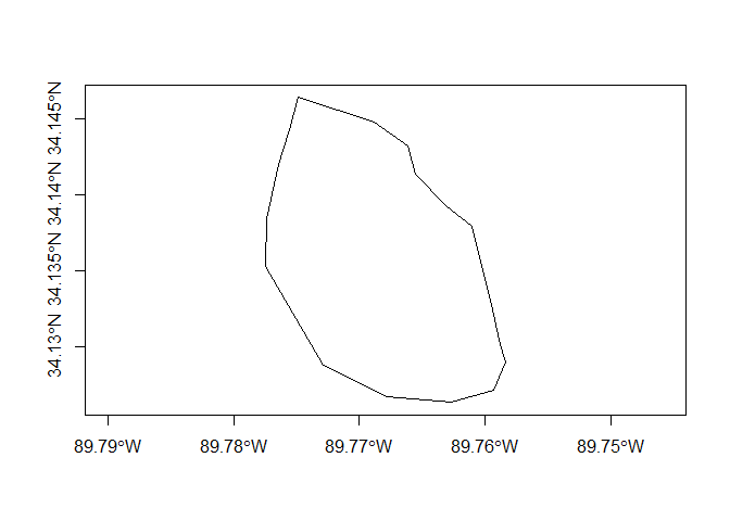
Now you can do nice things like plot the polygon.
plot(xy,axes=TRUE)
You can even work among different projection systems. The code below projects the polygon to UTM zone 16.
xy_utm<-spTransform(xy,
    CRS("+proj=utm +zone=17 +datum=NAD83"))
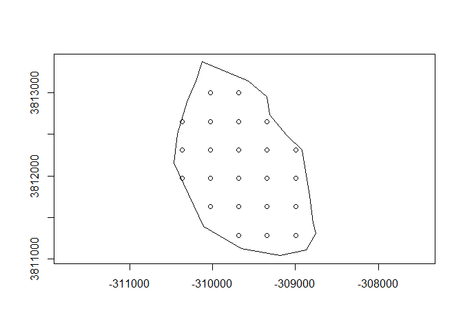
Using the spsample() function you can sample the polygon in varying
ways, below is a regular sample from a random initial location.
xy.points.reg <- spsample(xy_utm, n = 23, type = "regular") # n is sample size
You can look at the sites on the lake.
plot(xy_utm,axes=TRUE)
points(xy.points.reg)
You can also look at the xy coordinates and upload them to your GPS!
xy.points.reg

## SpatialPoints:
##              x1      x2
##  [1,] -309685.0 3811284
##  [2,] -309341.8 3811284
##  [3,] -308998.6 3811284
##  [4,] -310028.2 3811627
##  [5,] -309685.0 3811627
##  [6,] -309341.8 3811627
##  [7,] -308998.6 3811627
##  [8,] -310371.4 3811970
##  [9,] -310028.2 3811970
## [10,] -309685.0 3811970
## [11,] -309341.8 3811970
## [12,] -308998.6 3811970
## [13,] -310371.4 3812313
## [14,] -310028.2 3812313
## [15,] -309685.0 3812313
## [16,] -309341.8 3812313
## [17,] -308998.6 3812313
## [18,] -310371.4 3812657
## [19,] -310028.2 3812657
## [20,] -309685.0 3812657
## [21,] -309341.8 3812657
## [22,] -310028.2 3813000
## [23,] -309685.0 3813000
## Coordinate Reference System (CRS) arguments: +proj=utm +zone=17
## +datum=NAD83 +ellps=GRS80 +towgs84=0,0,0